A few weeks into our first monsoon season at AeroZona, the desert gave us our first land-restoration project.
Strong winds knocked down two dead palo verde trees on the property. We could have cut them up and hauled them away. Instead, we started looking at the washes running across the farm and asking a different question:
Could the trees that came down in one storm help us prepare the land for the next one?
The answer led us to check dams: simple, low structures placed across small washes, gullies, and drainage channels to slow runoff, capture sediment, reduce erosion, and give water more time to soak into the soil.
It is an old idea, but one with growing relevance in the desert Southwest.
USDA Agricultural Research Service scientists have studied check dams just a few hours southeast of us in southern Arizona, documenting how low, porous structures can help repair incised channels and increase landscape resilience.
And with NOAA currently reporting a greater than 90% chance that the developing El Niño will reach the very strong category during fall and winter 2026–27, this feels like an especially good time to learn how water moves across our land so we can be ready when rain does arrive.
First: What Is a Check Dam?
Despite the name, the kind of check dam we are talking about is not a miniature reservoir.
A check dam is a low, usually porous structure placed across a small drainage channel. Its job is not primarily to stop water. Its job is to change what that water does as it moves through the landscape.
USDA researchers describe loose-rock check dams as low barricades placed across modest channels. Water can pass through and over them, but its velocity is reduced.
That difference matters.
Fast-moving stormwater can pick up soil, deepen washes, enlarge gullies, and carry valuable sediment and organic matter off the property.
Slow the water down and a different sequence can begin:
slow the water → drop the sediment → increase infiltration → encourage vegetation → stabilize the soil → slow future water even more.
That positive feedback loop is one of the reasons these deceptively simple structures can gradually change a degraded drainage.
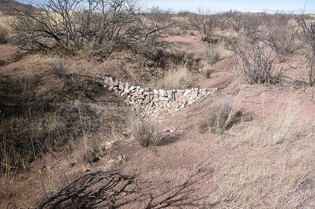
A low check dam near Tombstone, AZ. waits for a rain event to do its job of slowing down water and storing sediment after flow events in small run off channels to heal eroding watersheds. Mary Nichols (D4622-1)
Suggested caption: A loose-rock check dam across a small drainage near Tombstone, Arizona. USDA researchers studied dozens of similar structures to document their effects on erosion and sediment accumulation.
Why Desert Washes Need a Different Approach to Water
In much of the Southwest, rainfall does not arrive evenly.
Long dry periods can be interrupted by intense storms capable of producing significant runoff in a very short time. In semiarid environments, researchers describe erosion as being strongly influenced by relatively infrequent but high-magnitude rainfall events that can produce runoff carrying large quantities of sediment.
That is exactly why a dry wash should not be mistaken for an unimportant part of the landscape.
A wash may be bone dry almost every day of the year and then suddenly become the primary pathway carrying water across a property.
Once runoff becomes concentrated into a channel, it can begin cutting downward. As the channel becomes deeper, more water is confined inside it. That water can move faster, which causes additional erosion and makes the channel deeper still.
Eventually, instead of water spreading across a broad portion of the landscape, it may race through an incised wash and leave the property.
A check dam interrupts that cycle.
It introduces a small amount of roughness and grade control into the channel.
Instead of trying to eliminate the wash, we are trying to help it become slower, wider, more stable, and more connected to the surrounding soil.
What the Research in Southern Arizona Found
One reason this practice caught our attention is that there is unusually relevant research from our own state.
In 2008, USDA Agricultural Research Service scientists installed 37 loose-rock, semi-permeable check dams in two small watersheds on the Santa Rita Experimental Range in southern Arizona. Researchers compared what happened after installation with decades of previous watershed records.
The results are fascinating.
Over four years, the structures retained approximately 75 metric tons of sediment—about half of the measured sediment yield—and filled more than 80% of their original sediment-storage capacity.
The researchers did not detect a meaningful reduction in runoff from the largest storms.
That is an important distinction.
Check dams are not magic flood-control devices.
But the number of runoff events generated by smaller storms decreased by about 60%, while sediment accumulated behind the structures.
Long-term photographs told another part of the story.
USDA reported that in suitable small channels, some gullies that had been worsening each year became nearly filled with accumulated sediment behind check dams in only three to four years. Vegetation then began establishing in the newly deposited, moister soil.
Over roughly a decade of monitoring, photographs showed soil gradually rebuilding in formerly eroded channels while vegetation returned.
That is much closer to our goal at AeroZona than simply “capturing water.”
We want to help the landscape hold onto soil, organic material, moisture, and eventually vegetation.
Rock Isn’t the Only Option
Loose rock is probably the most recognizable check-dam material in the Southwest, but check dams can also incorporate logs, branches, brush, and combinations of wood and stone.
That matters to us because our first available building material arrived courtesy of the monsoon: two dead palo verde trees.
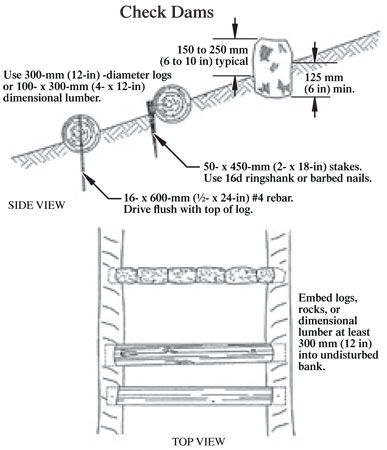
Forest Service guidance documents the use of log check dams and emphasizes several principles that translate well to small-scale woody structures: substantial pieces of wood should be secured rather than simply thrown into the channel, the ends can be embedded or “keyed” into stable banks, and smaller woody debris can be placed on the upstream side to help trap sediment and close large openings.
So when we say we are “chopping up the palo verde,” we do not mean turning the trees into a pile of small loose pieces and dumping them into a wash.
The larger trunks and limbs are actually the valuable structural pieces.
Our approach is closer to:
larger wood = structure
smaller branches = filtration and roughness
incoming sediment = eventual fill
vegetation = long-term stabilization
Loose woody debris that is not anchored can become moving debris in the next flood, potentially creating a problem farther downstream. That is one reason placement and stability matter.
This Forest Service illustration is an excellent companion to this section because it shows logs extending into undisturbed banks rather than simply lying loose across a drainage.
The Most Important Principle: Slow Water, Don’t Block It
A successful check dam should usually remain permeable.
Water needs a controlled path through or over the structure.
USDA’s southern Arizona researchers intentionally constructed loose-rock structures that could move or partially come apart during an unusually powerful storm. ARS researcher Mary Nichols described this as allowing the structures to fail gracefully rather than backing up a large volume of water behind a rigid barrier.
That concept is particularly useful for a small farm project.
We don’t want to create a solid dam.
We don’t want to create a pond in a wash.
And we definitely don’t want to move a wash from one side of the property to the other.
We want to introduce enough resistance to reduce velocity while still allowing a major storm to move through the system.
For that reason, cementing a small restoration check dam into place can sometimes defeat one of the advantages of this kind of low-tech structure.
The goal is resilience, not rigidity.
Shape Matters: Give the Water Somewhere to Go
One of the easiest mistakes is building a barrier that is highest in the middle and lowest near the banks.
That encourages water to flow around the ends of the structure.
Once water begins cutting around an edge, it can erode the bank and eventually create an entirely new channel around the check dam.
Instead, the structure should provide a deliberate low point or spillway near the center of the wash.
Forest Service guidance specifically recommends a central depression so water is directed toward the middle rather than “eating out” the banks. Other Forest Service guidance describes channel structures built in a shallow V or U shape, with the apex upstream and the center lower to focus flow toward the middle of the channel.
Think of the structure less like a wall and more like a very shallow, permeable weir.
Viewed from upstream:
bank ↘︎ low center ↙︎ bank
The edges are securely connected to the banks.
The center provides the preferred overflow path.
And the downstream side should be able to absorb the energy of water dropping over the structure without immediately creating a new scour hole.
Key the Structure Into the Banks
Water is extraordinarily good at finding weaknesses.
If a log simply stops where it meets the side of a wash, water may find the seam between the wood and soil and enlarge it.
Professional designs often address this by keying the structure into the sides of the channel—extending structural material into stable bank material rather than merely placing it against the surface. Forest Service documentation of log check dams describes end logs being keyed into adjacent streambanks.
At AeroZona’s scale, this does not necessarily mean major excavation.
It does mean paying close attention to the connection between the structure and the wash bank.
If water has an easier path around your check dam than through its center, eventually it will probably take it.
One Check Dam Is Good. A System Can Be Better.
A series of small structures can often accomplish more than one large structure.
Instead of forcing one dam to absorb the entire elevation change and energy of a drainage, several low structures create a sequence of small steps.
This mimics the logic of natural grade controls.
One commonly used design principle is sometimes described as head-to-toe spacing: the spillway elevation of a downstream structure is approximately level with the channel bed near the next structure upstream.
The exact spacing depends on channel slope and structure height.
The important idea is this:
More slope = structures generally need to be closer together.
Less slope = structures can generally be farther apart.
For our purposes, this is something to observe and adjust rather than something to apply from a universal spacing chart.
Every wash is different.
Sediment Is Part of the Design
At first glance, a check dam may look like it is “filling up.”
That can actually mean it is working.
The structure reduces water velocity, allowing sand, silt, gravel, seeds, leaves, and other material moving through the wash to settle behind it.
Over time, the channel immediately upstream can begin rising.
That is called aggradation, and in an incised drainage it can be exactly what we want.
USDA’s Arizona research documented significant sediment accumulation behind check dams and concluded that these depositional areas have potential to support watershed restoration.
Plants can then begin colonizing those deposits.
Roots stabilize the accumulated soil.
Plant stems provide additional resistance to flowing water.
More sediment is captured.
Eventually, the biological structure may become as important as the original check dam.
That is when this gets really interesting.
The check dam is not necessarily the final landscape feature.
It can be the scaffolding that allows the landscape to begin repairing itself.
What Can Go Wrong?
Check dams are simple. They are not foolproof.
Water goes around the ends
Usually a sign that the center spillway is too high, the sides are too low, or the structure is poorly connected to the banks.
Water cuts underneath
Called undercutting or piping. This means water has found a route underneath the structure instead of through or over it.
A scour hole develops downstream
Some scour is natural whenever water drops over an elevation change. Too much can undermine the structure.
The entire structure washes away
That may indicate the material was inadequately anchored, the structure was too large for the materials used, or the drainage carries more energy than expected.
It may also simply mean the storm exceeded what a low-tech structure could reasonably handle.
Remember: graceful failure can be preferable to creating a rigid obstruction that produces a larger flood hazard.
Loose wood travels downstream
This is particularly relevant to our palo verde project.
Branches and logs need enough anchoring, interlocking, mass, or bracing that an ordinary storm does not simply turn the structure into floating debris.
The check dam creates a new problem
A structure near a driveway, road, culvert, building, fence, utility, or neighboring property deserves much more caution.
Slowing water in the wrong place can redirect it somewhere you absolutely do not want it.
Maintenance Is Part of the Project
A check dam is not a “build it and forget it” structure.
USDA’s Arizona research specifically identifies maintenance as one of the keys to long-term performance.
That makes every storm an opportunity to learn.
After significant rainfall, we can walk the washes and look for:
erosion around the ends;
undercutting;
displaced branches or logs;
downstream scour;
new sediment deposits;
changes in the width or depth of the channel;
newly germinating vegetation; and
places where the water clearly wanted to go somewhere different than we expected.
One of the simplest monitoring tools is also one of the best: repeat photography.
USDA researchers photographed their Arizona check dams annually for more than a decade, creating a remarkable visual record of sediment accumulation and vegetation recovery.
We can do the same thing at AeroZona.
A permanent photo point, a measuring stake, and a few observations after every meaningful storm can turn a tiny farm project into our own long-term experiment.
A Note About Washes and Permitting
There is another important point for anyone considering this practice:
Owning the property does not necessarily mean every drainage on it can be modified without regulatory review.
Under Section 404 of the Clean Water Act, the U.S. Army Corps of Engineers regulates placement of dredged or fill material—including dams and dikes—into waters that fall within federal jurisdiction.
Arizona also distinguishes perennial, intermittent, and ephemeral surface waters; ADEQ defines an ephemeral surface water as one that flows or pools only in direct response to precipitation.
Whether any particular desert wash falls under federal or state regulatory requirements is a site-specific question.
That does not mean every small hand-built erosion-control structure requires a federal permit.
It means that before altering a large wash, significant drainage, mapped waterway, flood-control feature, or channel connected to another regulated water, it is worth checking with the appropriate agencies rather than assuming that “dry most of the year” means unregulated.
Small land-restoration projects and engineered dams are very different things.
When in doubt, ask.
Our Plan at AeroZona
We are starting small.
The two fallen palo verdes give us locally available material and an opportunity to work on a few of the smaller drainage features crossing the farm.
Our first structures will be deliberately modest.
We will use larger trunk and limb sections as structural material, incorporate smaller branches on the upstream side where appropriate, keep the structures porous, maintain a lower overflow point near the center, and watch carefully to see how water responds.
Then the monsoon gets to grade our work.
If a dam captures sediment, we’ll document it.
If water goes around it, we’ll figure out why.
If a piece moves, we’ll rebuild.
If vegetation begins appearing in newly deposited soil, we’ll watch what survives.
And if we discover a wash carrying more water than a hand-built structure should be asked to manage, we’ll leave it alone until we better understand the drainage.
This is less about imposing a finished design on the desert than beginning a conversation with the landscape.
The Bigger Idea: Keep Rain Where It Falls
AeroZona is being built around the idea that farming in the desert requires us to think differently about resources—especially water.
That applies not only to how we irrigate crops but to how we manage the entire property.
Rain falling on fifteen acres is a resource.
So is sediment.
So is dead wood.
So are the natural drainage patterns that show us exactly where water already wants to travel.
The goal isn’t to capture every drop or eliminate every wash.
It is to learn how to slow, spread, infiltrate, and make better use of the water that already reaches us.
Two dead palo verdes came down during a monsoon.
Soon, parts of those trees will become small structures in the washes that carried the stormwater across our farm.
And if they do their job, the next storm may leave behind a little more soil, a little more moisture, and eventually a little more life than the one before it.
That’s the kind of infrastructure we’re interested in building.
Not infrastructure that fights the desert.
Infrastructure that learns how to work with it.
Sources & Further Reading
For readers who want to dig deeper, particularly useful resources include research by the USDA Agricultural Research Service’s Southwest Watershed Research Center on check dams at Arizona’s Santa Rita Experimental Range, the related University of Arizona research on sediment retention in semiarid watersheds, and USDA Forest Service guidance on log and channel check-dam construction.
Leave a Reply